
Location: Queensland, Australia
Last Update: Thursday December 14, 2023 08:53 am (AEST)
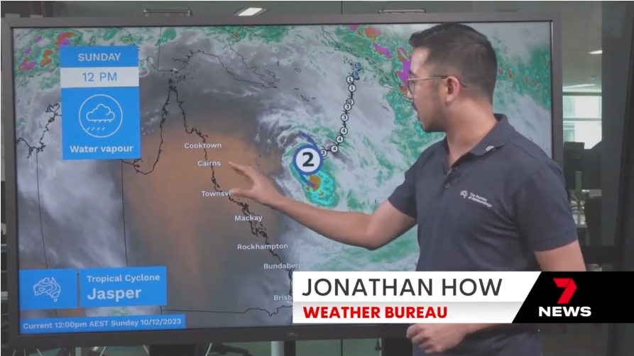
As Tropical Cyclone Jasper intensifies off the coast of Queensland, authorities are closely monitoring its trajectory and urging residents to stay informed and prepared. The cyclone, currently categorized as a Category 1, is expected to bring severe weather conditions, including heavy rain, strong winds, and potential storm surges. As of the latest updates from the Bureau of Meteorology (BOM), Intensity: The tropical low maintains sustained winds near its center of 55 kilometers per hour, with wind gusts reaching up to 85 kilometers per hour. Location: Positioned within 20 kilometers of 15.8 degrees South, 144.7 degrees East, it is 165 kilometers northwest of Cairns and 75 kilometers southwest of Cooktown. Movement: It is moving west at a speed of 13 kilometers per hour.
Ex-tropical cyclone Jasper is no longer at tropical cyclone intensity; nevertheless, the likelihood of impacts persists, including heavy to intense rainfall and damaging wind gusts, accompanied by showers and thunderstorms.
Interestingly, the name Jasper is both a boy's name and a girl's name meaning "bringer of treasure". The ancient boys' name Jasper is popular internationally in a range of forms, including Casper and Gaspard, and now Jasper is beginning to be used for girls in the US.


Expected Impact:
DESTRUCTIVE winds reaching speeds of up to 140 km/h are anticipated to form between Wujal Wujal and Innisfail starting early Wednesday morning. GALES featuring DAMAGING WINDS of up to 120 km/h are forecasted along the Queensland coast and adjacent ranges from Cape Flattery to Townsville, encompassing Cairns, beginning today. These DAMAGING WINDS are projected to penetrate inland towards Palmerville and Chillagoe after the cyclone makes landfall on Wednesday.
GALES with DAMAGING WINDS may potentially extend as far north as Cape Melville on Wednesday, contingent upon the course of Cyclone Jasper. A separate severe weather warning is currently in effect for DAMAGING WIND GUSTS in coastal and island areas between Cape Upstart and the Whitsunday Islands; additional details can be found in that advisory.
HEAVY RAINFALL, capable of triggering FLASH FLOODING, is expected to manifest from early Wednesday morning between Cape Flattery and Ingham. Anticipated six-hourly precipitation ranges between 100 to 150 mm, with isolated coastal and adjacent range falls of up to 250 mm. Over a 24-hour period, rainfall totals are predicted to range between 150 to 250 mm, with isolated areas potentially experiencing up to 350 mm.
A flood watch is currently in place for the North Tropical Coast, sections of the Cape York Peninsula, and the Gulf Country. As the cyclone nears the coast, a STORM TIDE is projected between Cooktown and Townsville during high tides today and Wednesday. The potential for minor flooding along the foreshore exists due to large waves. Residents in areas susceptible to this flooding are advised to take precautionary measures to safeguard their property and be ready to assist neighbors.
Preparedness and Safety Measures:
Evacuation Orders: Residents in high-risk areas are strongly urged to comply with evacuation orders issued by local authorities. Emergency shelters have been set up in safe locations for those needing refuge.
Emergency Kits: Ensure that emergency kits are prepared, including essential supplies such as non-perishable food, water, medications, important documents, and clothing. Don't forget to include supplies for pets.
Communication: Stay informed through official channels, including updates from the Bureau of Meteorology, local emergency services, and government agencies. Follow social media accounts and official websites for real-time information.
Secure Property: Undertake necessary preparations to secure your property, such as reinforcing doors and windows, clearing gutters, and relocating outdoor furniture and objects that could become projectiles in strong winds.
Ongoing Monitoring:
The trajectory and intensity of Cyclone Jasper are dynamic and may undergo alterations. Residents are strongly encouraged to stay vigilant and stay abreast of updates from authoritative sources. Queensland Fire and Emergency Services (QFES), alongside other pertinent agencies, are engaged in concerted efforts to guarantee the safety and welfare of the community, leveraging their resources and expertise.
Given the evolving nature of the situation, prioritizing safety remains paramount. Immediate action should be taken as deemed necessary. Queenslanders are urged to foster a sense of community by supporting one another during this challenging time. It is imperative to adhere to the guidance provided by emergency services, including the State Emergency Service (SES), to effectively navigate and mitigate the impact of Cyclone Jasper on the community. Stay tuned for further updates as the situation develops.
Information Sources: The content provided here is a culmination of efforts from various sources, including our in-house Research Team, Channel 7 & Channel 9 News, and the Bureau of Meteorology (BOM) - Australia. We acknowledge and credit these entities for their contributions to the information presented.